Работа с тренажером в режиме реального времени:
Если вы хотите выполнить весь тест последовательно(задания 1-2), нажмите кнопку 1.
Если вы хотите начать со второго задания нажмитекнопку 2.
Если вы хотите прослушать образец чтения текставслух нажмите кнопку 3.
Если вы хотите просмотреть или выполнить заданиябыстрее, чем предложено в автоматическом режиме,используйте на слайдах кнопку далее.


Task 1. Imagine that you are preparing a project with your friend. You have foundsome interesting material for the presentation and you want to read this text to yourfriend. You have 2 minutes to read the text silently, then be ready to read it out aloud.You will not have more than 2 minutes to read it.
Read the text silently (2 мин.)
The first maps were drawn by explorers to help them find their wayhome and show people where they had been. The maps showed theshape of the land, distances between places and special features suchas caves and old trees. Nowadays, maps show the towns and villages,and the roads, railways, rivers and mountains. Symbols are used toshow all the different things on a map and there is a key to explain whatthe symbols stand for.
Over the centuries, people explored most of the Earth and put togetherthe map of the world we use today. Maps of the world or large areas areoften either “political” or “physical”. The political map shows territorialborders. The purpose of the physical map is to show features ofgeography such as mountains, soil type or land use including roads,railroads and buildings.
Read the text aloud (2 мин.)


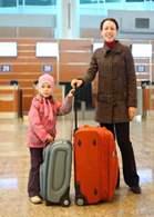
These are photos from your photo album. Choose one photo to describe toyour friend.
You will have to start speaking in 2 minutes and will speak for not more
than 2 minutes (12–15 sentences). In your talk remember to speak about:
where and when the photo was taken
what/who is in the photo
what is happening
why you keep the photo in your album
why you decided to show the picture to your friend
You have to talk continuously, starting with: “I’ve chosen photo number… ”

where and when the photo was taken
what/who is in the photo
what is happening
why you keep the photo in your album
why you decided to show the picture to yourfriend
You have to talk continuously, starting with:
“I’ve chosen photo number… ”
1
1
Speak for not more than 2 minutes (12–15 sentences).
In your talk remember to speak about:
https://english-study-cafe.ru/

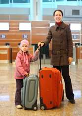
2
2
where and when the photo was taken
what/who is in the photo
what is happening
why you keep the photo in your album
why you decided to show the picture toyour friend
Speak for not more than 2 minutes (12–15 sentences).
In your talk remember to speak about:
You have to talk continuously, starting with: “I’ve chosen photo number… ”
https://english-study-cafe.ru/

3
3
where and when the photo was taken
what/who is in the photo
what is happening
why you keep the photo in your album
why you decided to show the picture to yourfriend
You have to talk continuously, starting with:
“I’ve chosen photo number… ”
Speak for not more than 2 minutes (12–15 sentences).
In your talk remember to speak about:
https://english-study-cafe.ru/
The first maps were drawn by explorers to help them find their wayhome and show people where they had been. The maps showed theshape of the land, distances between places and special features such ascaves and old trees. Nowadays, maps show the towns and villages, andthe roads, railways, rivers and mountains. Symbols are used to show allthe different things on a map and there is a key to explain what thesymbols stand for.
Over the centuries, people explored most of the Earth and put togetherthe map of the world we use today. Maps of the world or large areas areoften either “political” or “physical”. The political map shows territorialborders. The purpose of the physical map is to show features ofgeography such as mountains, soil type or land use including roads,railroads and buildings.
Прослушайте образец чтения вслух данного текста